
What international law actually says about Scarborough Shoal
Who owns a reef and how much sea it carries are two different legal questions. The 2016 ruling answered parts of the second one and none of the first.

Scarborough Shoal sits in the South China Sea, roughly 120 nautical miles (about 220 kilometers) west of Zambales, on Luzon. The Philippines calls it Bajo de Masinloc (also Panatag Shoal), China calls it Huangyan Dao, and Taiwan, which calls it Democracy Reef, claims it too. Arguments about it blend three things: what the law says, what a tribunal found, and what governments claim. This explainer keeps them apart.
1. The legal framework
The main treaty is the United Nations Convention on the Law of the Sea (UNCLOS), adopted in 1982. The Philippines and China are both parties. UNCLOS measures sea zones outward from a coastline's baseline, in nautical miles (one nautical mile is 1,852 meters).
- Territorial sea, up to 12 nautical miles (Article 3). The coastal state has sovereignty here, much as on land (Article 2), but foreign ships keep a right of innocent passage (Article 17).
- Contiguous zone, up to 24 nautical miles (Article 33). A buffer for enforcing customs, tax, immigration and health rules.
- Exclusive economic zone (EEZ), up to 200 nautical miles (Articles 55 to 57). This is not sovereignty. The coastal state gets "sovereign rights" over fish, oil, gas and other resources, while other countries keep freedom of navigation and overflight (Article 58).
- Continental shelf (Articles 76 and 77). The seabed and subsoil, normally to 200 nautical miles and sometimes beyond, with control over seabed resources.
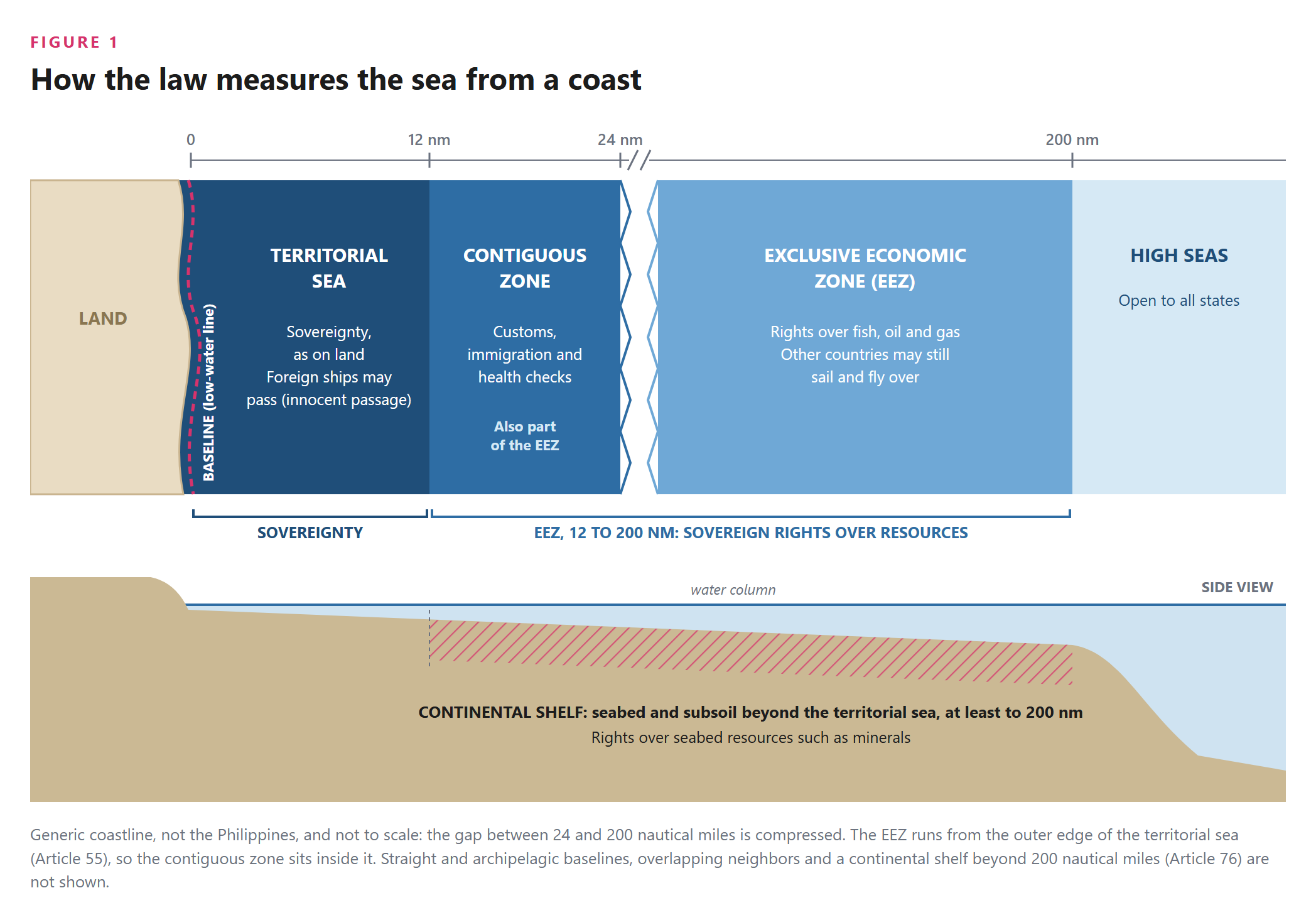
Land first, sea second. UNCLOS tells you how much sea a piece of land generates. It does not tell you who owns the land. Sovereignty over islands and reefs is decided by general international law on acquiring territory, which sits outside the Convention.
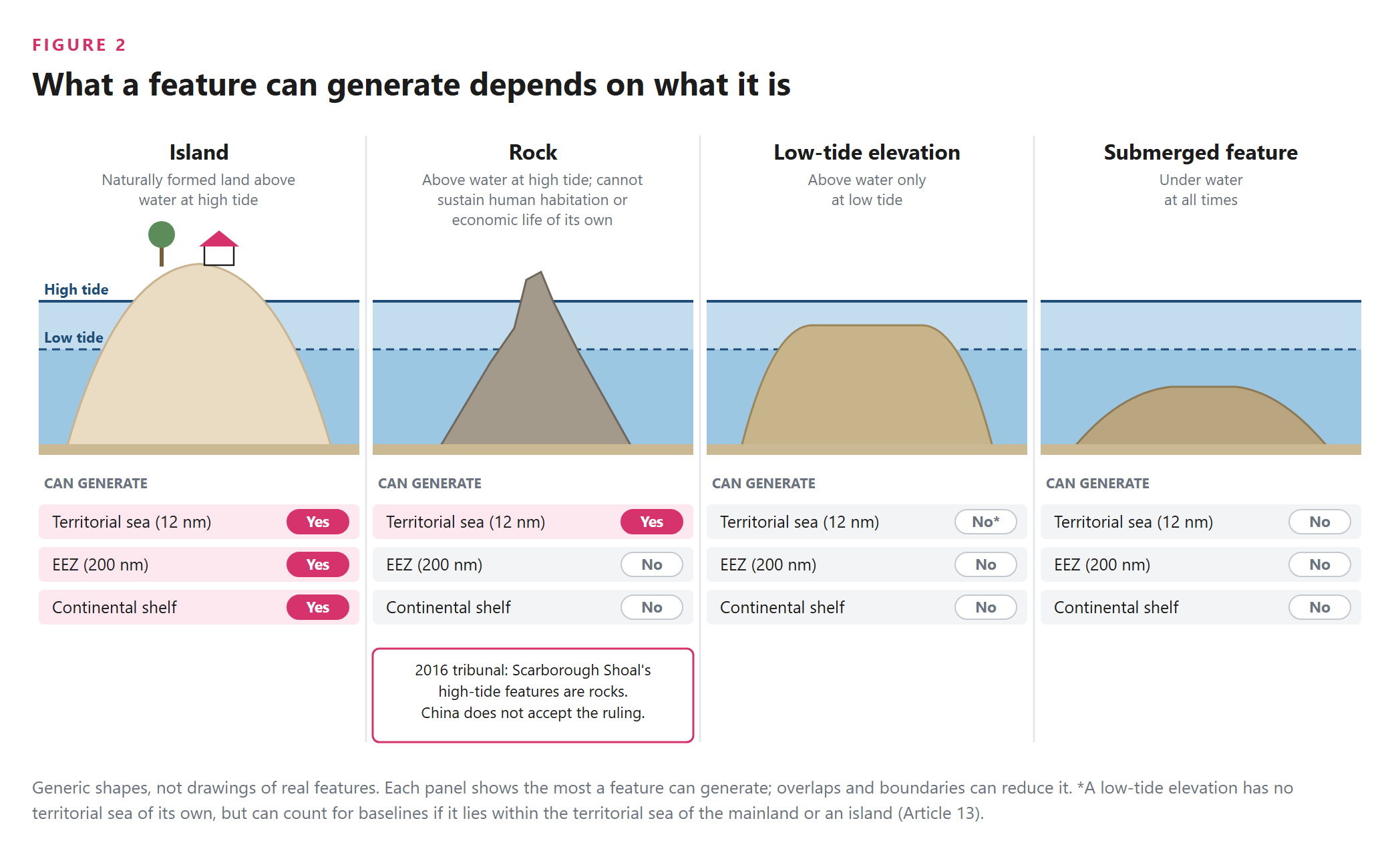
Classification is the hinge. What a feature generates depends on what it is:
- An island is naturally formed land above water at high tide. It can carry the full set of zones (Article 121).
- A rock "which cannot sustain human habitation or economic life of [its] own" gets a 12-mile territorial sea but no EEZ or continental shelf (Article 121(3)).
- A low-tide elevation shows only at low tide and generates no territorial sea of its own (Article 13).
- A submerged feature generates nothing.
Classification alone can mean 12 miles of sea or 200.
Disputes and their limits. Part XV of UNCLOS sends many disputes to compulsory settlement. Article 298 lets a state opt out of some categories, including boundary delimitation; China did so in 2006. Under Article 296 a decision binds only the parties to that dispute, and no international body enforces it.
2. What the 2016 ruling found
In 2013 the Philippines took China before a five-member tribunal under Annex VII of UNCLOS, with the Permanent Court of Arbitration as registry. China refused to take part, which the tribunal held did not stop the case (Annex VII, Article 9). Under Article 288(4), the tribunal itself decides any dispute over its own jurisdiction; China argues it had none. The tribunal ruled on jurisdiction in October 2015 and issued its final award on July 12, 2016.
On Scarborough Shoal, the tribunal found:
- The shoal is above water at high tide, so it generates a 12-mile territorial sea.
- It is a rock under Article 121(3): it "generates no entitlement to an exclusive economic zone or continental shelf."
- Fishers from the Philippines, China and other countries had traditional fishing rights there, and China violated them by halting access after May 2012. The tribunal added that it would reach the same conclusion if the Philippines blocked Chinese fishers.
- Chinese law enforcement vessels created a "serious risk of collision" with Philippine vessels in April and May 2012.
- China breached its duty to protect and preserve the marine environment, including at Scarborough Shoal.
More broadly, the tribunal found no legal basis for China to claim historic rights to resources within the "nine-dash line" beyond what UNCLOS allows.
What it did not decide. The tribunal stated that it "does not rule on any question of sovereignty over land territory and does not delimit any boundary." It said what zones the shoal can carry and who may fish there, not whose territorial sea it is. Its Scarborough findings also do not state what applies in the waters beyond 12 nautical miles from the shoal, so this explainer does not either.
3. Government claims and interpretations
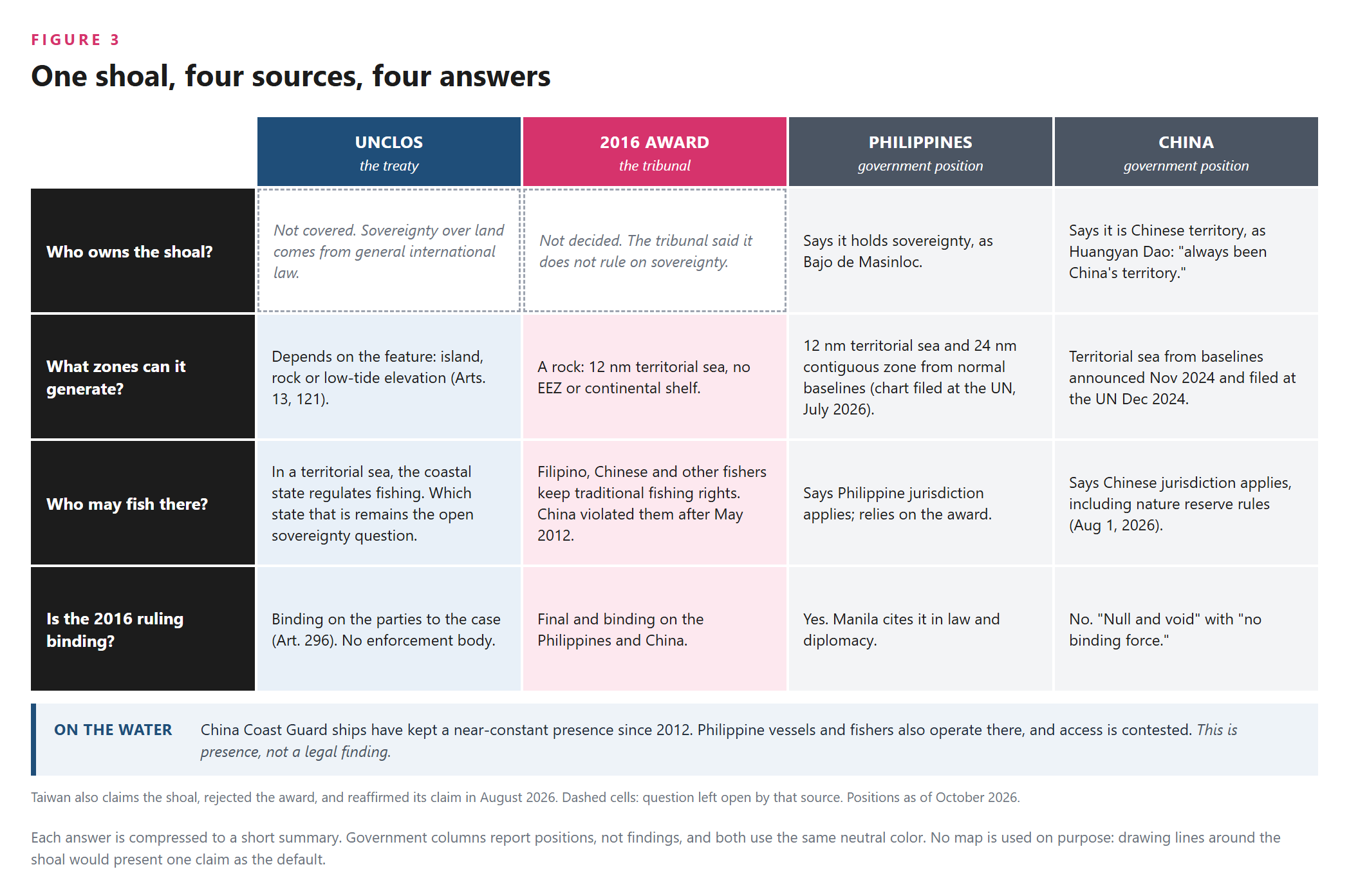
The Philippines says Bajo de Masinloc is "a longstanding and integral part of the Philippines over which it has sovereignty and jurisdiction." A 2009 law (RA 9522) placed it under the "regime of islands." The 2024 Maritime Zones Act (RA 12064) provides that the shoal generates a 12-nautical-mile territorial sea and a contiguous zone from 12 to 24 nautical miles. On July 29, 2026, Manila deposited with the UN Secretariat an official nautical chart (NAMRIA Chart 1567) showing the shoal's normal baselines and those two zones, citing Article 16 of UNCLOS, Philippine law and the 2016 award. The foreign ministry announced the deposit on July 31.
China says "Huangyan Dao has always been China's territory." Its foreign ministry declared the award "null and void" with "no binding force," and argued that the case was really about sovereignty and delimitation, which fall outside the tribunal's reach. On November 10, 2024 China announced territorial sea baselines around the shoal, and on December 2, 2024 it deposited them with the UN. It approved a national nature reserve there in September 2025 and issued management measures for it on August 1, 2026. On July 31, 2026 it called the Philippine baselines "illegal, null and void."
Taiwan, which was not a party to the case, also claims the shoal and also rejected the award. It reaffirmed its claim on August 2, 2026, after Manila's chart deposit.
Obligation, position, presence
Three different things are easy to confuse:
- A legal obligation is what the treaty or award requires. Under Article 296, the award binds China and the Philippines. China disputes that the tribunal had jurisdiction.
- A government position is what a state says the law means or whether it accepts a ruling. China rejects the award; the Philippines relies on it.
- Practical presence is who is actually on the water. China Coast Guard ships have kept a near-constant presence near the shoal since 2012, and their numbers have risen sharply since 2025. China's military and coast guard held drills there on August 1 and September 27, 2026, and patrols in October; Chinese state media said in September that China's control around the shoal now extends beyond 24 nautical miles. Philippine coast guard and fisheries vessels also operate in the area, and in October 2026 delivered fuel to Filipino fishers there. Access is contested. No international police force exists to settle that.
The three can point in different directions at the same time, and that gap is where each new incident at sea plays out.
Still open: who holds sovereignty over the shoal, whether either side's baselines are valid, and where any boundary would run. The 2016 award answered none of these.
Glossary
- Baseline: the line, usually the low-water line along the coast, from which all sea zones are measured.
- Nautical mile: 1,852 meters. All UNCLOS distances use it.
- Territorial sea: waters up to 12 nautical miles from the baseline, under the coastal state's sovereignty.
- Innocent passage: the right of foreign ships to pass through a territorial sea without threatening the coastal state.
- Contiguous zone: waters from 12 to 24 nautical miles, where a state can enforce customs, tax, immigration and health rules.
- Exclusive economic zone (EEZ): up to 200 nautical miles. The coastal state has rights over resources, not full sovereignty.
- Sovereignty vs. sovereign rights: sovereignty is a state's full authority over its territory and territorial sea. Sovereign rights are limited to specific purposes, such as exploiting resources in an EEZ.
- Continental shelf: the seabed and subsoil beyond the territorial sea, with rights over minerals and other seabed resources.
- Entitlement: the zones a feature or coast is legally capable of generating.
- Delimitation: drawing the boundary where two states' entitlements overlap. A separate step from entitlement.
- High-tide feature: land above water at high tide. It generates at least a territorial sea.
- Island (Article 121): naturally formed land above water at high tide, capable of carrying the full set of zones.
- Rock (Article 121(3)): a high-tide feature that cannot sustain human habitation or economic life of its own. It gets a territorial sea only.
- Low-tide elevation (Article 13): visible only at low tide. It gets no territorial sea of its own.
- Historic rights: rights a state claims from long-standing use, outside the treaty's zones.
- Traditional fishing rights: long-standing fishing by individuals, which the tribunal held survived UNCLOS at Scarborough Shoal.
- Nine-dash line: the line on Chinese maps enclosing most of the South China Sea. Beijing has never fully specified its coordinates or legal basis.
- Annex VII arbitration: the default UNCLOS procedure for compulsory arbitration when parties have not chosen another forum.
- Permanent Court of Arbitration (PCA): an intergovernmental body in The Hague that served as registry for the case. It is not a UN court and did not decide the case itself.
- Article 298 declaration: an optional statement excluding some dispute types, such as delimitation, from compulsory settlement.
- Final and binding (Article 296): a ruling settles the dispute between the parties to that case. It does not bind third states and has no enforcement mechanism.
- Bajo de Masinloc / Panatag Shoal / Huangyan Dao / Democracy Reef / Scarborough Shoal: names for the same feature, used by Filipino, Chinese, Taiwanese and English-language sources.
- West Philippine Sea: the Philippine name for the parts of the South China Sea within its claimed zones.


